Sunday, January 20, 2013

Joining the Oregon Trail

I hitched my trailer and left my farmer friends to resume the trail of my great grandfather. Before I left the area though, I went to Lakefield, MN to get another perspective about the Massacre from the local museum director. Then, I had lunch with the dairy farmer's son Lee, after he showed me the latest in fiber optic communications at the local phone and digital service provider's office where he now works. It's a far cry from what I saw in two major telecom development labs in the early 1990s. The "cutting edge" fiber technology I was shown then seems almost primitive compared to what Lee is working with today.

It was early afternoon when I finally left Minnesota to head southwest. I passed endless cornfields that were burned by the summer drought. Now trained in the ways to read the condition of the crops by my farmer friends, I soon realized that much of the year's production of corn would be lost to causes beyond mans' control.

My route would take me down the Iowa side of the Missouri River to Omaha, where I would then head west, first on the I-680 bypass, and then on I-80 to my next camp stop in Gretna, NE. Before retiring for the night, I again checked the history of the 10th Regiment.

The next notation regarding Company D of the 10th, places Jerome's unit at Ft, Kearney, NE, one of the early stops on the Oregon trail, in August, 1857.
  •  [Company] A left Fort Ripley July 8, and D Fort Ridgely July 21, and at the end of August both companies were in camp near Fort Kearney, Neb., en route to Utah.

Friday, July 27 - Next stop - the U.S. Air Force ?????

I left the campground at Gretna the next morning. Imagine my surprise just ten miles down the road when I crossed the Platte River and saw the signs for the Strategic Air and Space Museum

This was an unplanned stop - but one I couldn't pass it up. The 33 aircraft housed in this remarkable facility all played important roles in the military history of our country during my lifetime, from the B-17, B-25, and B-29 of WW II, to the cold war era planes of the Strategic Air Command of the 1950s, to the U-2 and SR-71 reconnaissance planes of the 1960s, one of which is still flying.

My first picture as I entered the museum is of the SR-71 Blackbird. I had photographed one of these as it flew into Paine Field near my home for an air show in the 1980s. This plane, designed and built by Lockheed in the 1960s was way ahead of its time.

The next plane that brought back memories was the B-36 Bomber. This plane had the distinction of being the first capable of reaching a target on another continent and returning home without requiring refueling.

I remember it as the only aircraft I could identify by the unique sound of its six 28-cylinder radial engines purring smoothly as they passed high over the Nevada home of my youth in the late 1940s and early 1950s.
You can judge the size of this behemoth by this view which I took while standing under the tail of the aircraft. You can see the three starboard prop engines and two of the four jet turbines that power the plane from this angle. When you consider that the wingspan of this plane is over 2/3rds the length of a football field, you can also begin to get an idea of the size of this building, which houses all of its 33 aircraft under cover.

One could easily spend an entire day, or even days in this place. My stop here was all too brief. My parting view of the facility includes my truck and trailer in the foreground.


The story of the Mormon Handcarts on the Oregon Trail

When I made a stop at a roadside rest about two hours later, I realized that I had taken the convenient modern route of I-80 out of Lincoln on my way to Ft. Kearney instead of following the Platte River as the pioneers and my great granddaddy did. My inadvertent detour saved me an extra hour of driving.

In the process, I drove the longest straight stretch of highway in the interstate system; the 72 miles of I-80 between Lincoln and Grand Island in Nebraska.

Mormon Island, one of many in the Platte, is today a Nebraska State Recreational Area near Grand Island, NE. It's history is depicted on several signboards that I read as I stretched my legs.

It was here I learned that the settlers using Conestoga Wagons pulled by oxen weren't the only ones moving west. The remarkable story of the Mormon migration using hand drawn carts was revealed to me.
It was explained that each family using a cart was allowed 17 lbs of possessions per adult and 10 lbs per child. Tents and other provisions for the part were carried in wagons that accompanied each group.

  • Ten handcart companies formed, made up of approximately 3,000 people pushing and pulling carts 1,300 miles from Iowa City to Salt Lake City in an average of 125 days.
A poem on one of the signboards tells the story.

Thirty minutes after leaving Mormon Island, with I-80 following the Platte and the historic trail, I arrived at Ft. Kearney State Park. It was near here that Jerome's unit camped.

Ft. Kearney was only 9 years old in 1857, having been constructed in 1848 to support the massive migration to California when gold was discovered there. A Wikipedia entry tells us:

  • The fort grew rapidly into an important trail stop. By June 1849, Woodbury noted in his journals that 4,000 wagons had passed the fort so far that year, mostly on their way to California. The fort accumulated large stores of goods for travelers, with the directive of selling them at a beneficial cost to the emigrants. Specifically, the commander of the fort was authorized to sell goods at cost to emigrants, and in some cases of hardship, to give goods to them for free. In 1850, the fort acquired regular once-a-month mail service with the arrival of a stagecoach route between Independence, Missouri and Salt Lake City. It was the first regular mail service established along the trail.
To read the complete Wikipedia story of  Ft. Kearney as we know it today, go here.

My picture of the Nebraska Historical Marker sums up the story of this way station to the west.


I concluded my drive on I-80 at Ogallala, NE, having crossed most of the southern part of the state in a one day 310 mile drive. In the morning, I would follow the settlers' trail along the North Platte using US Highway 26, noting the natural landmarks that emigrants used to mark their progress.


Thursday, January 17, 2013

Down on the Farm

The next two days would be all about getting to know my friends of twelve years - face to face. Together, we fought a long battle to cure electrical problems that were affecting their cows - all long distance. In the process, I came to know some details about the family, such as the fact that their names were Chuck and Wanda, with a son, Lee.

So, there was my Wanda and me, and then this pair. It was confusing, so we decided early on that they would be referred to as the Udder Chuck and Wanda. That kept everything straight.

Leaving Ft. Ridgely, it was a relatively short (86 mi.) drive to the dairy farm. I arrived early in the day.
My route was roughly that taken by Jerome's company in 1857 in response to the massacre.

As I arrived, a view from the farmhouse was interesting. I'm told there are over 20 cats helping to control the rodents.

Barnyard Cats


Another convenient coincidence, besides our names, is the fact that the Udder Wanda was raised near the site where the massacre that I wanted to investigate took place, near Spirit Lake, IA.

So, while the Udder Chuck minded the farm, Wanda and I took a 17 mile trip to tour the 1857 massacre site and a nearby museum.

Spirit Lake Massacre, and the story of a survivor

The settlers in this region were, as was often the case, on the edge of a frontier, not always under the protection of a nearby army garrison. Such was the case at Spirit Lake. The natives, displaced from their hunting grounds, were often in dire straights when it came to providing for their families. Such was the case as the harsh winter of 1856-57 took its toll. The history of the Iowa National Guard paints a pretty clear picture of what happened at Spirit Lake.

Confrontations were often the result of misunderstandings between the settlers and the natives. In this case, a settler had killed the brother of a Sioux Chief, Inkpaduta, who then took out his revenge on several settlements.

Abbie Gardner was just 13 years old at the time of the massacre. More than 30 settlers were killed, including her family, but she, with 3 other women from nearby settlements, were taken captive. Abbie was ransomed a few months later, and would live out her life in her reconstructed cabin, retelling her story of the massacre.

The Udder Wanda shows me Abbie Gardner's Cabin
 As I learned when I visited the museum in Lakefield, MN, there were two sides to the story of the massacre, one told by Captain Bee, the commander of Company D of the 10th Infantry, and one by those who responded from Ft. Dodge. One can second guess the motives and actions of the various players, but I prefer to let readers examine stories and draw their own conclusions.


We returned to the farm


Wanda and I returned to the farm and I was treated to a fine dinner out with a wonderful family. I look forward to more visits with them, both by email and in person.

I'll be bouncing back and forth between the present and the past for the next few posts as I follow the 10th Regiment on their way west during the balance of 1857.

Next stop for Jerome - Ft. Kearney, Nebraska. 


Sunday, December 23, 2012

On to Fort Ridgely and points beyond

With my disappointment in Minneapolis (finding Fort Snelling closed on Monday) behind me, I called some long time friends - dairy farmers - in the southern part of the state. I told them I would be arriving at their farm on Tuesday evening after an overnight stay in the campground at Fort Ridgely State Park.

Their suggestion that I should try their favorite authentic German restaurant in nearby New Ulm was a good one.

Fort Ridgely was a relatively short 100 miles or so from Minneapolis. I arrived there in mid-afternoon, set up my trailer, and then drove to New Ulm, only about 16 miles away.

It was a little too early for dinner, so I stopped by the local tourist information center and asked what they recommended for a tourist with a free hour or so.

I was directed to the top of the hill on Center Street, where I found the Hermann Monument. Check out this tab for the history of the monument and some interesting background.

I can personally verify that there are 100 steps to the top. Here are a few pictures of my adventure.

Hermann Monument in New Ulm, MN
I climbed, and carefully counted the stairs, until I was standing at the railing just under Hermann's feet. The view from the top will give you some idea of what the local terrain is like - gently rolling hills.
New Ulm, and the Minnesota River Valley from Hermann Monument
So, now it was time for dinner. I went to the authentic German restaurant recommended by my friends and enjoyed a good dinner.

Authentic Bavarian Restaurant

Fort Ridgely - History in a cemetery

It was back to the campground, where I discovered that there was nearby graveyard associated with the Fort of years past.

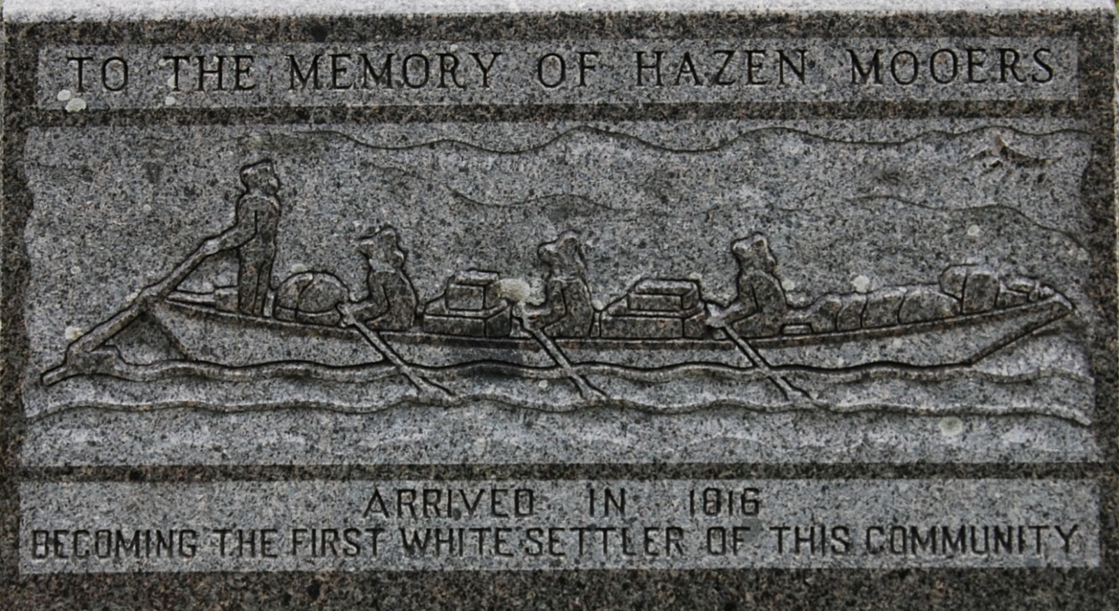
You can learn a lot about the history of a place by studying the monuments and headstones in a cemetery. Here was a very informative monument at Ft. Ridgely for a pioneer named Hazen Mooers.

Hazen Mooers - First White Settler
 The inscription on the top reads:

  • "Hazen Mooers, one of the pioneers of the fur trade with the Sioux, came to the No. West in 1816 conducted a trading post at Big Stone Lake for 15 years. In 1835, established a post at Little Rock, 5 miles below Fort Ridgely. In 1853 secured contract for erecting the first govt. bldgs. at Lower Sioux Agency. This work completed, retired to a small farm home in the valley just below Fort Ridgely. There he died Apr. 3, 1857. Age 68 yrs."
Might Jerome have met Hazen Mooers? He was at the fort for the last year of Hazen's life, so it's possible.

The face of the monument reveals even more about life in the 1800s in Minnesota.

I noted the boat depicted in this scene resembles the dugout canoes that were key to the success of the Lewis and Clark expedition. This blog provides some history of such boats.

More history of the 10th Regiment

Jerome's time at Ft. Ridgely included a call for his Company D to respond to a massacre that occurred during March, 1857. Word reached the fort on March 19th.

Jerome's unit sees action


  • "Captain B. E. Bee with "D," numbering forty-eight rank and file, left the post at noon of the same day and proceeded down the valley of the Minnesota River to South Bend."
The history goes on to describe the conditions, which included deep drifts that had thawed so they would not support the men and sleds. The company made slow progress over several days.

  • "By marching the command in column of fours and relieving the men at the head of the column, at short intervals, they were able to break a road through the deep and heavy snow. They would then stack arms, and the soldiers would fall back to the assistance of the sleds. In spite of these difficulties the command marched fifteen or eighteen miles a day."
The unit reached the area of the Massacre in March 28th
  • "On the afternoon of March 28th, after a weary march of twenty miles, the command arrived in sight of the Indian village, which was situated in a thick grove of timber and apparently consisted of about thirty lodges.
Not surprisingly, the small Sioux band, led by war chief Inkpaduta, had fled. Capt. Bee had the unit continue the pursuit for another three days, but finally:
  • "...his men being foot-sore and weary from a march of one hundred and forty miles under difficulties not easily portrayed, Captain Bee was obliged to return disappointed to his main camp.

Back to the present

It was Tuesday morning. Having spent a night near the fort where Jerome had served, I was now ready to trace his path to Spirit Lake, where the massacre took place.


On the way, I would finally meet and spend a couple of days with, my friends of twelve years. Until this day, we only knew each other through phone conversations, emails, and letters - mostly discussing electrical problems on their dairy farm. They were gracious hosts, as you will see in my next post.


Thursday, December 13, 2012

In Minnesota at last...


After my second night in Bismarck, ND, I resumed my trip on I-94 into Minnesota. I noticed that I would be passing through Fergus Falls. That brought back memories of my first few weeks on my new job in Washington state, in 1966.

My first job for the company where I would work for 38 years, was to communicate with customers and potential customers, providing requested information about our products and their operation.

I was suspicious one day when I received a request for quote from the Otter Tail Power Company in Fergus Falls, MN.

Why was I suspicious?

Well, the 1960s featured the tv show, Rocky and Bullwinkle, and many episodes took place in the fictional Frostbite Falls, MN. Hmmm - Otter Tail, Fergus Falls...was this a practical joke hatched by my co-workers?

I quietly researched the company and the town in the company library (not so easy before the internet), and found that both the company and the city were real, so I answered the quote request without mentioning my suspicions to anyone.

Since I would be in Fergus Falls anyway, I decided to find the Otter Tail Power Company offices. I took this picture before resuming my trip.
Otter Tail Power Company

Sunday night in greater Minneapolis

I arrived at my campground, near Minneapolis in the evening on Sunday, July 22nd.

After setting up my trailer and finishing dinner, I took advantage of the WiFi service, offered by most campgrounds these days, to plan my visit to Jerome Mann's first duty station - Fort Snelling.

Imagine my dismay when I discovered that Monday was the one day of the week that the fort, now a State Park, was closed. As a result, I took no pictures and was left to rely on internet sites to provide some history.

It turns out that in the same year that the Lewis and Clark party was wintering at Ft. Mandan, Lt. Zebulon Pike (for whom Pike's Peak, CO would later be named) was tasked with exploring the Mississippi River and selecting sites for forts. The site selected near what is now Minneapolis would become Ft. Snelling in 1825.

 I learned this and more in the Expansionist Era pages offered by the Minnesota Historical Society.

Jerome's early life as a soldier


My great grandfather was in Company D of the 10th Infantry Regiment, and went through basic training at Carlisle Barracks near Harrisburg, PA before being deployed at Ft. Snelling.

This, from the history of the 10th Regiment.

August, 1855
  • To facilitate the necessary military instruction, Companies A, B, D, G and K were placed under the supervision of Lieut.-Col. Smith, and C, F, H and I, under that of Major Canby.
September, 1855

  • Preparations were commenced for the transfer of the regiment to its first regular station.
  • Hardee's Rifle and Light Infantry Tactics were first used for instruction in the regiment. 
Note: You can view the contents of Hardee's book, as published in 1856, here.

October 13, 1855
  • The Field, Staff, and A, B, C, D, F, G, H, I and K, left Carlisle Barracks near Harrisburg, PA.
October 17, 1855
  • Regiment arrived at Galena, IL. Headquarters and A, C, D, I and K left by steamboat for Fort Snelling.
Judging by the distance between Carlisle Barracks and Galena, IL (805 miles), and considering that their travel only took 3 days,  I can only assume that the regiment moved by train to Galena for this deployment.

October 20, 1855
  • Headquarters and A, C, D, I and K arrived Fort Snelling.
 Apparently, there were early problems with troops going AWOL and deserting the service.

This note appears in the Regiment history.

  • Of the first five hundred men enlisted for the regiment, sixty-six were born in the New England States, one hundred and forty-nine in the Middle and Western States, and two hundred and eighty-five were foreign born. From this total enlisted, two hundred and seventy-five deserted before completing their enlistment.
Marksmanship was stressed in training, as noted in this description of the training regimen.
March, 1856
  • A system of regimental instruction was instituted. Exercise in drill, target practice and marching was zealously kept up. It was impressed on the soldiers that their duties as "Light Infantrymen" required of them a complete knowledge of the use of the rifle, and especially deliberation and calmness in firing, that each shot might be effective. The ranges for target practice were two, three, four, five, six and seven hundred yards. Five shots were allowed at 200 yards, seven at 300, nine at 400, nine at 500, and ten each at 600 and 700 yards. The target used was a piece of white cotton, seven feet long and four feet wide, stretched on an iron frame. The bull's-eye was a circle eight inches in diameter, four feet from the ground and equidistant from the sides, painted black, with the exception of a small spot in the centre left unpainted to determine the centre accurately. Outside the bull's-eye were two black rings concentric with it, with radii of six and nine inches respectively. All shots were recorded and the men classified according to ability. Squads and individuals were practised, and the percentage of hits to misses governed the score, record in the cases of individuals being kept of bull's-eye hits.
I can't help wondering how Jerome might have scored in these exercises.

June, 1856
  • Regimental headquarters and four companies, under Colonel Alexander, left Fort Snelling June 24th of this year, and arrived at Fort Ridgely June 30th, taking station there.
Company D must have been one of those that moved with headquarters to Fort Ridgely, because it was from there, in the following winter, that Jerome's company was called to investigate a massacre.

Fort Ridgely, and the Spirit Lake Massacre will be the subject of my next segment.


Wednesday, December 12, 2012

Where Theodore Roosevelt Roamed...

My first stop in North Dakota was the little town of Medora.  Here I found the entrance to the south unit of the Theodore Roosevelt National Park.

I knew that Roosevelt ranched in the North Dakota Badlands, but I soon found out that his focus on conservation efforts later in life, when he was our 26th president, originated with his experiences here.

                                               North Dakota Badlands near Medora, ND

I drove about 10 miles into the park, towing my trailer on a primitive gravel road, but soon turned around and resolved to make a later trip where this would be a destination rather than a casual stop.

There was much more here to explore than I would have time for on this trip. The park, and the 
vacation destination town of Medora are on my list for a more relaxed, but also more thorough, week of activities sometime in the future.

Meanwhile, if you're interested in learning more about Theodore Roosevelt's early life, or the history and current activities available in Medora, you can explore more here.

Theodore Roosevelt and Conservation

Medora, ND - A Family Vacation Destination

My ultimate destination in North Dakota was the site of Lewis and Clark's winter encampment of 1804-05. My plans called for two nights at the KOA campground in Bismarck, with a day trip, sans trailer, to the reconstructed Corps of Discovery campsite and interpretive center in Washburn, about 40 miles to the north.

How it all began...

Washington D.C., June 20, 1803

    To Meriwether Lewis Esquire, Captain of the first regiment of Infantry of the United States of America.The Object of your mission is to explore the Missouri river & such principal stream of it as by it's course and communication with the waters of the Pacific ocean, whether the Columbia, Oregon, Colorado or any other river may offer the most direct & practicable water communication across this continent for the purpose of commerce.


Thomas Jefferson

 A year and a half later, the Corps of Discovery was encamped near a Mandan Indian village more than 1,000 miles on the Missouri River above St. Louis. They set about building a fort in which they would endure the harsh winter. I photographed this map at the interpretive center at nearby Washburn. It shows the path of the roughly 1,500 miles they would yet have to travel to reach the Pacific.
The blue dotted line showing Clark's return route on the Yellowstone River in this map approximates the path I followed on I-90 and I-94 to reach the fort on the bank of the Missouri River where I now stood. The artist George Catlin captured a scene at a Mandan village in 1837 that is how I imagine Lewis and Clark found it 33 years earlier. Bird's-eye View of the Mandan Village

And here is a bird's eye view of the Ft. Mandan replica.

Here are a few detailed pictures I took in the reconstructed replica of the fort built by the Corps.


View from the entry gate looking to the interior.
Store room for provisions that were packed in canoes and on horses for the trip
Officer accommodations for Lewis and Clark. 
Each room in living quarters had its own fireplace,
on the right in this view.
 Enlisted mens' accommodations

I reluctantly left Fort Mandan and took this shot of the nearby Missouri River. I imagine it looks much like it might have to the members of the Corps. nearly 200 years ago.
Across the wide Missouri

The next day's drive took me from North Dakota into Minnesota - destination - Minneapolis.

After a brief stop in Fergus Falls, MN, my next segment will begin to follow Jerome Mann, my great grandfather, on his five year adventure as an infantryman in the U.S. Army in the 1850s.